How to Use Contour Maps to Build Resilient Properties
In a world where supply chains are fragile, weather patterns are unpredictable, and centralized systems are increasingly unreliable, resilience is no longer a luxury—it’s a necessity. For landowners building off-grid homesteads or farms, the first step to an antifragile property is understanding the lay of the land. That’s where contour maps come in.
What a Contour Map Tells You
At first glance, a contour map is just a series of lines marking elevation. But for anyone planning a resilient property, those lines are a blueprint for ensuring access to sufficient resources during times of instability. They reveal how water flows, where frost settles, and which areas are naturally sheltered from the wind.
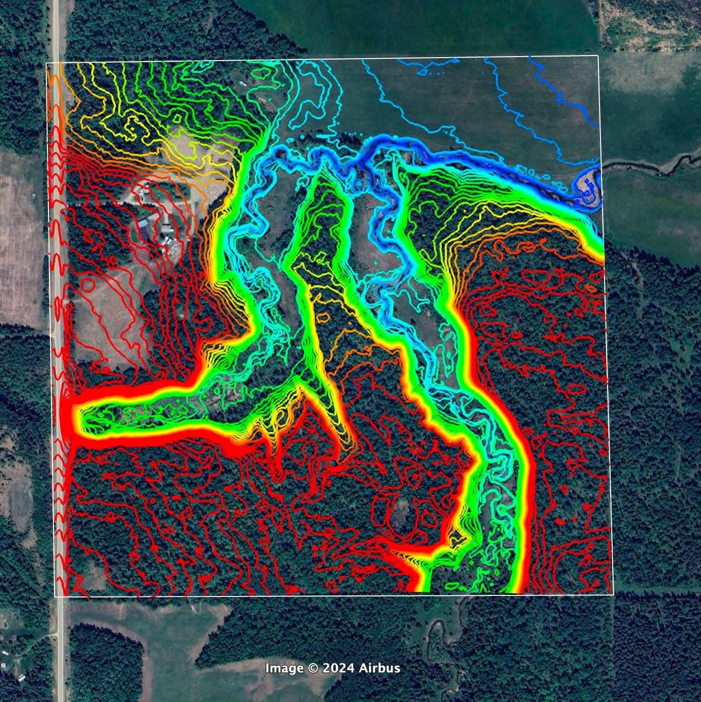
These insights can inform important property design decisions such as where to place food systems (e.g., gardens), water systems (e.g., swales), and energy systems (e.g., solar panels), as well as safe living zones that can withstand shocks.
Put simply: Contour maps turn raw land into an intelligent design.
Rob Avis—a renowned permaculturist and Chief Engineering Officer at the resilient homestead company 5th World—regularly relies on its contour map platform, Contour Map Generator, to inform property design during the diagnostic phase.
“A map is the closest thing a designer and land manager has to a Rosetta Stone,” said Rob. “It’s a non-linear tool that allows you to capture enormous amounts of data on a single page. If a picture is worth 1,000 words, a map is worth 50,000.”
Food Systems That Endure
Resilient food production means more than just planting crops—it means choosing the right locations for them. Contour lines show frost pockets, slopes that hold or lose heat, and areas where soil is most likely to accumulate.
By reading the land this way, you can:
Position greenhouses where they’ll get maximum sun and minimal wind exposure
Site orchards and perennial crops in microclimates that extend growing seasons
Design gardens that capture natural water flow instead of fighting against it
The result? Food systems that are less dependent on outside inputs and more capable of enduring extreme weather events.
Water Security Through Topography
Water is the cornerstone of resilience. On any property—whether five acres or five hundred—the ability to capture, store, and distribute water can mean the difference between abundance and scarcity.
Contour maps reveal the natural pathways of water. By working with these, you can:
Build swales and terraces that slow runoff and recharge groundwater
Identify ideal pond locations for reliable reserves
Direct overflow safely away from structures, reducing flood risk
A strategic landowner sees not just a hill or valley, but a potential water storage system.
Energy and Shelter Placement
For the resilience-minded, energy independence is just as critical as food and water. Contour maps guide the placement of solar arrays, wind turbines, and even geothermal systems by revealing exposure, slope orientation, and soil stability.
Structures, too, benefit from smart siting. A house placed just a few meters higher—or tucked against the right hillside—can mean greater protection from storms, less need for heating and cooling, and better long-term durability.
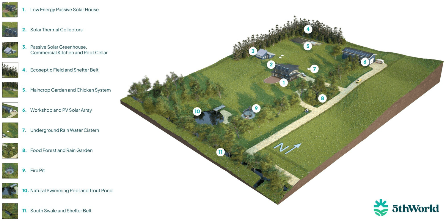
Caption: Here is an example of a 5th World off-grid property whose food, water, and energy systems are interconnected and work with the land's natural features.
Why Contour Maps Are the First Step
Before breaking ground, drilling wells, or planting trees, start with the map. Contour analysis transforms guesswork into strategy, ensuring every system on the property—food, water, energy, shelter—works with the land instead of against it.
In a future where resilience equals freedom, understanding your property’s topography isn’t just smart planning. It’s survival.
“When I first started teaching regenerative property design, I instructed students to draw maps by hand,” said Rob. “Now, we have tools like Contour Map Generator, which makes designing a breeze for any property larger than half an acre.”
5th World’s Contour Map Generator gives you a low-cost, science-backed way to plan smarter and avoid costly mistakes. Start with a free Basic Contour Map, and only pay for the additional insights you need.
Visit www.contourmapgenerator.com to learn more.


COURSES & EVENTS
RESOURCES
CONTACT
45.1841° N, 79.4085° W
Muskoka Ontario Canada
Copyright © 2025 Chris Outdoors. || Terms of Service | Earnings | Disclaimer | Privacy Statement